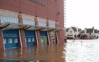
Two Years since the Carlisle Floods ...
Can you believe it?
It was such a surreal day. It was stormy the night before, and I had driven home from Newcastle in constant heavy rain. But when I woke to lovely blue skies I thought the worst was over. I didn't know that a couple of miles downhill in the centre of town all hell was breaking loose.
My plans were typical of a Saturday; a leisurely breakfast and perhaps some shopping later, who knows. I had a shower and started to dry my hair when after a few seconds, the power went off. It didn't come back on again for almost two days.
The house phone still worked - a quick call from my parents (who had been due to come for breakfast after their early shopping trip) told me that the whole heart of the town centre had been flooded, didn't I know? There was panic of the streets of Carlisle!
This I had to see for myself. So I got dressed and put a hat on the keep my wet head from getting any colder and walked down towards town.
The first glimpse I got of it was near the civic centre - a large council building built in the late 1960's.
Next to it is the Victorian Police Station.
Opposite, the new shopping centre and doors into Debenhams
Nearby, the view across the main Hardwicke Circus - every learner driver's nightmare. I searched for a picture of this area without water but can you believe it I couldn't see any - take it from me this is usually gridlocked with cars.
This area in the centre of town is deliberately left free of homes and buildings not only because it's right next to the major bridge over the river Eden, but also because planners know it is part of the natural flood plain. Hundreds of years ago, there were two tributaries which used to flow back together to form and island inbetween, and there were two bridges from the town over to the north bank. To this day, local people still say they are crossing "The Eden Bridges", when there's just one, and many don't know why!
The land inbetween, The Sands, was a sandbank used for markets, sporting events and other gatherings; for instance I remember it being used for funfairs in the seventies and eighties. Now, it is where the Sands Centre stands, a leisure centre used for - er - sports gatherings and suchlike.
The lowest part of the city is where three major rivers meet, in Bitts Park. This is the large open space where they hold the Race for Life every year. This is what it looked like when flooded:
This is why the main West Coast Railway line was closed:
Later that evening, a few of us gathered in a house with a coal fire and gas oven and cooked the perishable items from many of our fridges, and drank wine by candlelight.
The next day on a walk we passed a few lost souls from the local hostel, looking for their temporary accommodation. It was clear their only remaining undamaged possessions were in the small bags they were carrying.
For many local people the misery went on for months, and there are still people even now who are not back in their homes. Many of the homes flooded were bedsits and cheap housing, so they were less likely to be able to afford insurance. Hundreds of contractors - builders, plasterers, damp experts - came from miles away to make the most of the insurance bonanza. Some people were even ripped off by unqualified fraudsters wanting to make a quick buck.
Now, there are plans underway to change the flood defences around the city, which actually worked to hold in the floodwater rather than allow it to drain away. I almost bought a house on a one of the streets that I saw flooded ... there but for the grace of whatever....


No comments:
Post a Comment